Earthquake hazard zoning: An international effort conduction in Iran for Western and South Asia

As an international effort, this article is aimed to represent the important controlling factors for seismic hazard analysis (SHA) performed over the last 3 decades in Iran, Western, and South Asia.
After each major earthquake, the seismic source and ground motion models will be modified and there are always discussions on the reliability of the seismic hazard zoning maps and a comparison between the recorded and previously assessed ground motions.
This draws attention to the importance of input dataset and the level of knowledge of the seismic source parameters in the potential seismic regions (geometry and mechanical of faults, return periods, etc.)
The South Asia region is exposed to high seismic activities and are greatly influenced by the continental convergence and active crustal shortening between the African, Arabian, and the Indian plates to the NE (Northeast) and northward with respect to the Eurasian plate. According to the regional tectonic regime of the Iranian plateau, the focal mechanism solutions of most earthquakes are compressional, strike-slip, or a combination of these two mechanisms (Fig. 1).
The GPS-derived velocity field for the zone of interaction of the Arabian, African (Nubian, Somalian), and Eurasian plates indicates counterclockwise rotation of a broad area of the Earth's surface including the Arabian plate, adjacent parts of the Zagros and central Iran, Turkey, and Eurasia (Fig. 2).
Central Turkey (Anatolia) moves in a coherent fashion with internal deformation <2 mm/yr. The motion of Anatolia is bounded on the north by the right-lateral North Anatolian fault and on the southeast by the left-lateral East Anatolian fault. Relative to Eurasia, the southwestern Aegean-Peloponnisos moves toward the SSW (South-southwest). The similar measurements in the Iranian continent and northern Oman indicate that most of the shortening is accommodated by the Makran subduction zone and less by Kopet-Dag. The Central Iranian Block moves consistently with internal deformation smaller than 2 mm/yr.
In the western part of Iran, distributed deformation occurs among several fold and thrust belts. The maximum velocity (38 mm/yr) in the northern Ganges plains approximates the rate of convergence between the Indian and Eurasian plates. All these GPS analysis indicate high rates of deformation in the West Asian region and the Iranian Plateau, so that the region is exposed to all-round pressures caused by the collision of lateral tectonic plates.

Fig 1. Focal mechanism of the main earthquakes recorded in Iran during the last century. Dashed lines: borders of the 3 main tectonic zones of Iran. Solid line: major faults
Therefore, the geodetic, seismic and tectonic studies in the region confirm the existence of a complex active tectonic framework with high deformation rates, a part of which expressed in terms of earthquakes. This region experiences different earthquake magnitudes each year, some of them may reach Mw8 (e.g. 27 November 1945Mw8.1 Makran earthquake). Many destructive earthquakes with magnitude?7.0 have occurred during the last century such as the 1909 Silakhor, Boroujerd (Mw.7.3), 1930 Salmas (Mw.7.1), 1962 Bou'in-Zahra (Mw.7.1), 1968 Dasht-e-Bayaz (Mw.7.4), 1978 Tabas (Mw.7.4), 1990 Manjil (Mw.7.4), 1997 Ghaen (Mw.7.3), 2003 Bam (Mw.6.6), 2013 Savaran (Mw.7.8) in Iran; 1939 Erzincan (Mw.7.8), 1970 Gediz (Mw.7.2), 1976 Çaldiran–Muradiye (Mw.7.0), 1999 Izmit (Mw.7.6), 1999 Duzce (Mw.7.2), 2011 Van (Mw.7.1) earthquakes in Turkey; the Nuweiba earthquake south of the Dead Sea fault and in the Gulf of Aquaba in Egypt; the 1935 Quetta (Mw.7.7), 1945 Balochistan (Mw.8.1), 2005 Balakot (Mw.7.6), 2011 Dalbandin (Mw.7.2) and 2013 Awaran (Mw.7.7) earthquakes in Pakistan; and the 2002 Hindu-Kush (Mw.7.4) and 2015 Hindu-Kush (Mw.7.5) earthquakes in Afghanistan (Fig. 3).
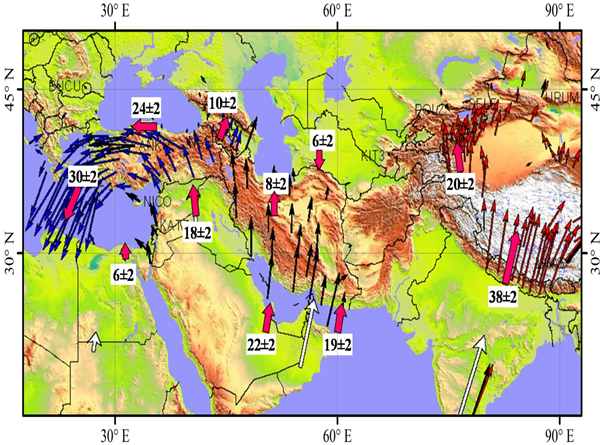
Fig 2. Horizontal velocity field for a major part of Alpine-Himalayan chain.
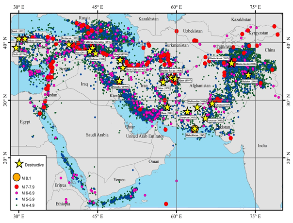
Fig. 3. Seismicity map of the Middle East region before declustering represented by epicenters of earthquakes (4?Mw). Yellow stars indicate some of the destructive seismic events (with 6.5?Mw) during the last century. Source of data: EMME earthquake catalogue (Zare et al., 2014).
After earthquakes (i.e. 1990 Mw7.3 Manjil earthquake and 2003 Mw6.5 Bam earthquake) some questions were raised on the reliability of the seismic hazard zoning maps and on the comparison between the recorded and previously assessed ground motions. These triggered the importance of input dataset and the level of knowledge of the seismic source parameters in the region (fault geometry and mechanics, return periods of large and destructive earthquakes, etc.)
Related efforts
The application of most popular seismic hazard analysis methods such as the deterministic seismic hazard analysis (DSHA) as well as the probabilistic seismic hazard analysis (PSHA) in this region is explained.
It should be noted that reliable seismic hazard studies depend on having a robust earthquake catalogue, good knowledge on the tectonic framework and rate of active deformation, and relevant attenuation model. The better input for hazard analysis results in more reliable the parameters and the seismic hazard assessments, so that precise input data such as comprehensive catalogues, seismicity parameters as well as characteristic of seismotectonic zones lead to decrease uncertainties of the analysis.
There have been several efforts to prepare uniform earthquake catalogues of the Middle East and Iran in the recent years such as a new earthquake catalogue of the Middle East region which has been developed consisting historical, early and modern instrumental events recorded between 1250 B.C. and 2006 (Zare et al., 2014).
This effort was undertaken under the framework of Global Earthquake Model (GEM) and Earthquake Model of Middle East (EMME) projects and the final goal was to establish a unified catalogue of seismicity by incorporating regional and international data to be used for homogeneous estimation of seismic hazard in the region. We noticed that there is not enough strong-motion metadata in most parts of the study region. Uncertainties associated with the seismic hazard analysis and level of success of the Poissonian method in the region is also presented.
The trend of such seismic hazard studies in South Asia have been initiated using deterministic approaches, continued with probabilistic approaches and finally linked to the spectral zoning maps. The trend in hazard mapping appears to cover the intensity assessment, realistic acceleration and the neo-deterministic approaches; the development of site specific seismic hazard analysis for the region should be based on the detailed integrated site characteristics database. This article is based on the context and a critical review of the seismic hazard studies that I performed during the last 28 years.
Mehdi Zare is professor of engineering seismology at the International Institute of Earthquake Engineering and Seismology (IIEES) in Tehran. He is also an associate member of the Iran Academy of Sciences (IAS) in Tehran, where he is now the Head of Geology Division in IAS. He can be reached at: mzare@iiees.ac.ir
Leave a Comment