Qom: A province of ancient beacons along historic routes
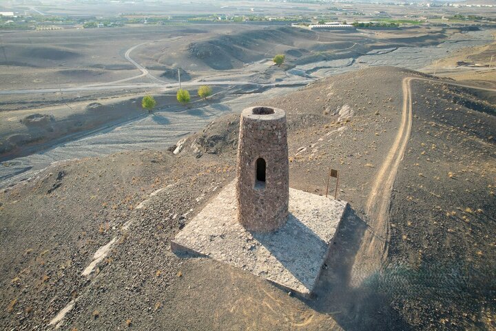
TEHRAN - Scattered across the mountains, plains and historic routes of Qom province, a group of ancient Meels, standalone beacon towers once used to guide travelers and caravans, offers a distinctive glimpse into the history of travel and communication in central Iran.
Often standing on elevated ground overlooking old roads and passes, the structures are among the lesser-known heritage sites of Qom. Their locations, architecture and relationship with ancient routes could make them compelling destinations for travelers, historians, architects and enthusiasts of Iran’s cultural heritage.
Speaking to ISNA, historian and researcher Hossein Sadeqi says Qom is unusual in having a relatively large concentration of historic Meels, with the structures spread across different parts of the province. Based on existing roads, the distance between some of them is estimated at around 50 kilometers.
The term Meel historically referred to a standalone beacon or light-bearing structure. Such towers were built beside important roads and routes, particularly in periods before and during the Islamic era, to help travelers and caravans navigate difficult terrain. Fires were traditionally lit at their upper sections, allowing people to identify the route during darkness or in fog.
Unlike minarets attached to mosques or other religious buildings, these structures were originally independent ones. According to Sadeqi, their functions included guiding travelers as well as communication and signaling. Their elaborate architectural features in some cases, however, have led researchers to consider whether certain examples served additional purposes.
Most surviving historic Meels in Iran date from the fourth to sixth centuries AH, although examples attributed to earlier periods also exist. Many were equipped with stairways leading to their upper sections, with some featuring separate spiral staircases.
Aliabad Meel
The stone Meel of Aliabad stands about 50 kilometers along the Qom-Tehran road, beside the historic stone castle of Aliabad. Built on an elevated hill, it is believed to have served as a landmark for caravans.
The tower is about 11 meters high and has an arched entrance approximately 1.5 meters wide. Spiral stairs lead toward the upper section. Stone and sarooj, a traditional Iranian waterproof mortar, were used in its construction.
Several rows of what appear to be reed pipes can be seen in the structure at a height of about three meters. Sadeqi suggests that these may have been incorporated to reduce the effects of ground vibrations.
The cylindrical structure has a base diameter of about 4.33 meters. Its association with the nearby Seljuk-era caravanserai and its construction style have led researchers to attribute it to the Seljuk period.
Imamzadeh Abdullah Meel
Another historic beacon stands outside the city of Qom along the old Qom-Isfahan road, near Cheshmeh Ali village. Located on high ground, the structure has a conical form and was once accompanied by a protective enclosure, of which only walls remain.
The Meel rises about 6.4 meters and has a base diameter of approximately 5.5 meters. Its exterior is built of rubble stone and gypsum mortar. The structure stands around 200 meters above the surrounding plain.
Its form and construction suggest that it dates from the Seljuk period.
Babak Meel
Babak Meel occupies one of the highest peaks of the northern mountain range overlooking the valley. From the tower, the surrounding valleys can be seen clearly.
Only about 3.7 meters of the northern section of Babak Meel survives. Its exterior consists of rubble stone and gypsum and sarooj mortar.
Chahak Meel
Chahak Meel lies in the Khalajestan district, east of Chahak village and north of the Vezva River, on high ground overlooking the surrounding plain.
Pottery from both the Sasanian and Islamic periods has been found in the area. Its masonry and architectural form have been compared with a Sasanian-era Chahar-Taq, leading to an attribution to the Sasanian period.
The surviving structure is about 4.6 meters high at its highest point and has a base diameter of roughly 5.1 meters. Its exterior is circular, while its interior follows a cross-shaped plan, recalling the architecture of Sasanian Chahar-taqs, or four-arched structures.
Shahrestan Meel
Shahrestan Meel stands in central Qom province, and it is attributed to the Sasanian period and is thought to have stood within the ancient settlement known as Shahrestan.
The area, now called Mazraeh Shahrestan, is believed to have been a fortified site in antiquity and a village by the fourth century AH.
The tower has been heavily affected by erosion and now resembles a cone-shaped structure. It stands about 7.5 meters high and was built of mud brick.
Safarali Meel
Safarali Meel rises on a mountain opposite Mount Sepor-e Rostam, west of Kaj village. The site commands extensive views over the surrounding settlements and plains.
The structure is about 6.8 meters high, with a base diameter of approximately seven meters. Its exterior is made of rubble stone and sarooj, while the interior was constructed without mortar.
Much of its interior is filled with rubble stone, while a circular chamber survives above it. The chamber has a floor diameter of about 3.45 meters and walls approximately 1.7 meters thick.
An opening on the eastern side faces Kaj village. The tower's elevated position provides views toward Mohammadabad, Korgol, Aliabad, Bayer Kalhar, Malek Qaleh and surrounding seasonal settlements.
Pottery found around the site includes prehistoric material as well as pottery associated with the Seljuk period. The latter has contributed to the attribution of the surviving Meel to that era.
Maghbulabad Meel
In Khalajestan, southwest of Maghbulabad village, another Meel survives at an elevation of about 1,893 meters above sea level and approximately 65 meters above the surrounding plain.
Its architectural style is attributed to the Seljuk period. The tower was constructed from local rubble stone and gypsum mortar and originally had a cylindrical form.
Only about 2.7 meters of its height survives today. Its strategic position is particularly notable: the tower stands at a point from which it could have served travelers using the historic routes connecting Saveh, Tafresh and Qom.
Although it has little decorative ornamentation, the arrangement of its masonry remains of architectural interest.
Meem Meel
Meem Meel, located in the village of Meem in Kahak district, resembles Safarali Meel but is smaller.
The structure stands roughly 85 to 90 meters above the surrounding plain and is about nine meters high. Its base diameter is approximately 4.62 meters.
Built of rubble stone and gypsum mortar, it has a conical exterior and an enclosed chamber inside. Its architectural similarities with other Qom beacons have led researchers to attribute it to the Seljuk period.
Rahjerd Meel
The stone Meel of Rahjerd stands near Dizijan village on the heights of Mount Zanbureh, overlooking a gorge and the Zavvarian passage in the Rahjerd area.
Approximately 4.25 meters of the structure survives. Its base diameter is about 6.3 meters, and it rises roughly 60 meters above the surrounding plain.
Its rubble-stone construction and gypsum mortar are similar to those used in other Seljuk-period Meels in Qom province.
Taken together, these structures form a scattered network of architectural landmarks that reflects the importance of movement across central Iran long before modern roads transformed the landscape. Their locations on high ground, near passes and along historic routes reveal a practical relationship between architecture and travel.
For modern visitors, the appeal of Qom's Meels lies partly in their isolation. Unlike major monuments located in urban centers, many of these towers survive amid mountains, plains and old travel corridors. Reaching them can therefore offer not only an encounter with historic architecture but also a sense of the landscapes through which merchants, pilgrims and caravans once moved.
AM
Leave a Comment