New challenges of disaster management in Iran

The Iranian plateau is located in a very seismically active region of the world and is known not only for its major catastrophic earthquakes but also for the disasters relating to natural hazards, especially earthquakes. About 2% of the earthquakes of the world occur in Iran but more than 6% of the victims of the world earthquakes during the 20th century are reported from Iranian earthquakes. This shows the high level of vulnerability in Iran.
The major items to be focused in order to prevent more casualties in major earthquakes over the last two decades in Iran are:
• Disaster risk management at national and local government levels.
• Integrated disaster management, technical systems, implementation, processes, and products.
• Improvement of resilient communities (national, regional, and local).
• Disaster management in hospitals and health systems.

Fig 1. Seismic hazard zoning map of Iran in terms of Earthquake Acceleration by (a): Iranian seismic building code (code number 2800), 2018; (b): IIEES Zoning Map 1999; (c): Mehdi Zare, EMME Model 2018; (d): Mehdi Zare, 2015.
After the earthquake hit Tabas in 1978 with Mw7.4, Manjil in 1990 with Mw7.3 and Bam in 2003 with Mw6.5, some discussions have been raised about the reliability of the different existing seismic hazards zoning maps (Fig. 1) and a comparison between the recorded and previously assessed ground motions. Thus, besides the several hazard maps developed during the last four decades for Iran, there are still ongoing challenges in hazard analysis.
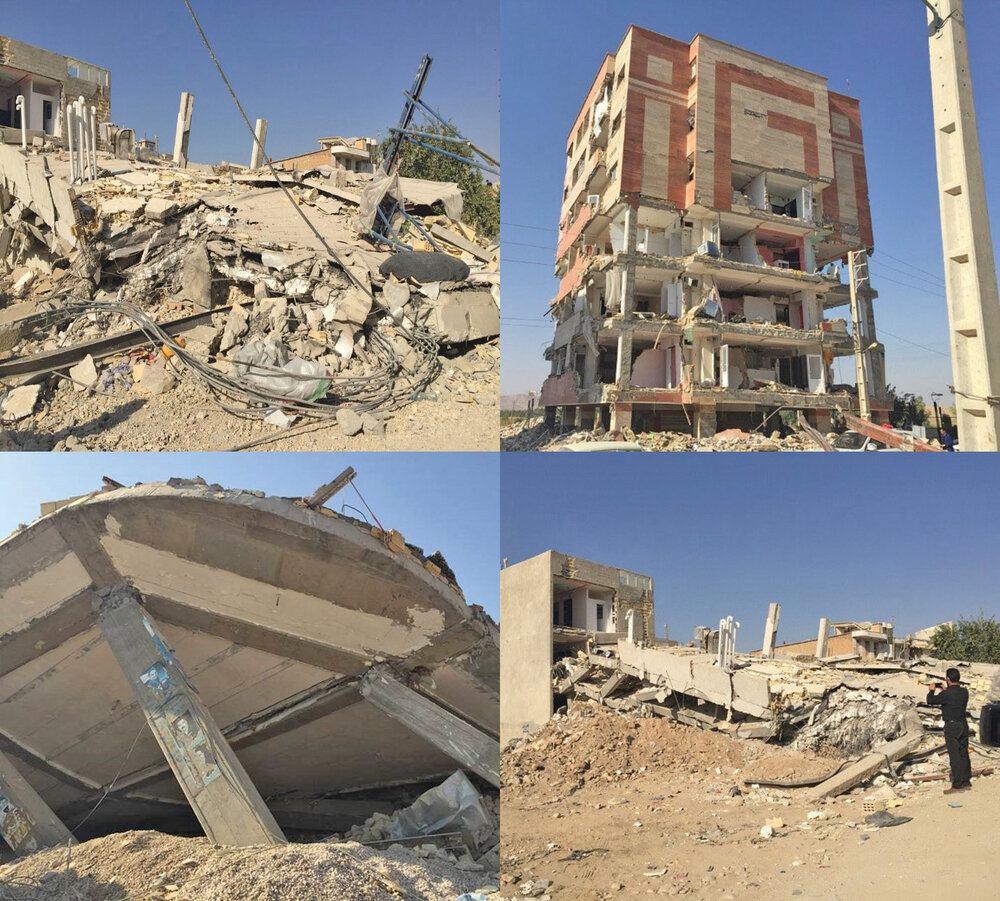
Fig. 2. Damaged newly-built complexes and collapsed buildings in Sarpol-e Zahab city.
A devastating earthquake with a magnitude of 7.3 at a depth of 18km struck west of Iran on November 12, 2017. The epicenter was in the Sarpol-e Zahab region within the Zagros Mountains. This study was focused on the damage distribution of the epicentral region and the adjacent areas. The study comprised the results of a reconnaissance visit headed by the first author to Kermanshah Province a week after the mainshock. Based on the field observations, damages to buildings, surface fissures and ruptures and landslides were determined. Based on intensity assessments, earthquake intensity was estimated to be about VIII for the epicentral region and around VI-VII for the cities of Qasr-e Shirin (on the EMS-98 scale) according to damages to the built environment.
Based on the field surveys and assessments, the maximum intensities and most of the destructions were reported in the cities of Sarpol-e Zahab and Qasr-e- Shirin in Kermanshah Province (Fig. 2).
With respect to the high seismicity and experience of destructive large-magnitude earthquakes, it reminds us that several cities, such as Tehran, Tabriz and Mashhad are exposed to high seismic hazards and risks, such as the one that occurred on 12 November 2017 in Sarpol-e Zahab, with Mw7.3. Considering the active tectonic setting of these important cities, more efforts for data provisions, seismic hazard investigations and risk assessments are necessary in order to reduce life and property losses.
With regard to the increasing growth of population in urban areas, the risk of natural hazards has become a matter of concern in earthquake-prone cities of Iran. The vulnerability of populated areas to natural disasters is partly a consequence of decades of spatial planning policies that have failed to take into account earthquake hazards and risks in land use development decisions. Therefore, it is critically important to implement and incorporate an earthquake and natural disaster reduction spatial planning. The communication and incorporating knowledge, technology in disaster management decision-making strategies is a must in actual Iran.
We are focused on “more resilient cities” as our local and regional task force for Iran to be conducted in governmental and NGO frameworks. Based on our annual plan for developing the risk communication and education in Iran, we apply the generic framework for risk reduction in order to ensure effective practices and tools in Iran.
In this framework, we aim to communicate and connect mayors, governors, councilors and other local government leaders in order to improve their knowledge and to put their effort and ordinary executive activities in a scientific national network.
There are now organized monthly workshops and educational seminars and short courses in major cities in Iran for this purpose. Where recently the "Instagram live" virtual webinars are used gradually, especially after the Coronavirus pandemic confinement and social distancing since the end of February 2020. In these new platforms, we are trying to discuss more easily with people even living in large distances and train how to build disaster resilience city and benefits, what kind of strategies and actions are required, and how to achieve these tasks.
**Mehdi Zare is professor of engineering seismology, International Institute of Earthquake Engineering and Seismology (IIEES), and an associate member of the academy of sciences of Iran
Leave a Comment